
|
Training, Open Source Programming Languages |
| Home | Accessibility | Courses | The Mouth | Resources | Site Map | About Us | Contact |
| For 2023 (and 2024 ...) - we are now fully retired from IT training. We have made many, many friends over 25 years of teaching about Python, Tcl, Perl, PHP, Lua, Java, C and C++ - and MySQL, Linux and Solaris/SunOS too. Our training notes are now very much out of date, but due to upward compatability most of our examples remain operational and even relevant ad you are welcome to make us if them "as seen" and at your own risk. Lisa and I (Graham) now live in what was our training centre in Melksham - happy to meet with former delegates here - but do check ahead before coming round. We are far from inactive - rather, enjoying the times that we are retired but still healthy enough in mind and body to be active! I am also active in many other area and still look after a lot of web sites - you can find an index ((here)) |
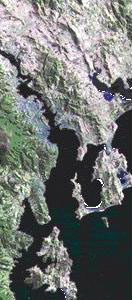
Hobart, Tasmania - Image Library
International images are interspersed with ones representing the subject area
you're browsing through if you visit our site from outside the UK where we're
based.
|
The city of Hobart is situated at the mouth of the Derwent River, a relatively
short river but wide and deep in its estuary. Urbanisation is evident
for some considerable distance along both sides of this rift valley which
was formed by faulting. Just several kilometres to the south-west of
the city, the land is heavily forested and mountainous, rising steeply
to Mount Wellington (1270m). This graphic is from the free map and
satellite image page of Geoscience Australia - http://www.auslig.gov.au/download/images.htm
Our image library data is stored in XML and parsed by a PHP script each time this page is called. We'll teach you how to generate pages dynamically from data in this way on our training courses - not only do we train in the technology, but we also use it in our own business! Images used on this web site are copyright Well House Consultants Ltd, or royalty free images (stock art) unless otherwise stated. |
 |
Other images in our library:
• Our Training Centre
• 1896 map of Melksham
• Ordnance Survey Mapping
• Austrian training
• Hobart, Tasmania
• London and a Highland croft
• Our Lady's Church, Brugge, Belgium
• Spring morning at Beach
• Sunrise at Beach
• Open Source Library
• A Bedroom at Well House Manor
• The lady on the bridge at Iford
• Joining instructions folder
• Clacker Brook
• Vancouver Skyline
• Supporting ironwork for Clevedon Pier
• Course and subject certification
• Swiss training
• Charlie the Cat
• Shaking hands
• Alarm clock
• Painting of Melksham Training Centre
• Melksham Training Centre
• Melksham Training Centre (older picture)
• Training in Germany
• Booking schedule
• Training in Denmark
• Edinburgh Castle
• The library at Ephesus
• Equipment in our training centre
• Spain - training courses
• Opentalk logo
• Safety Precautions
• Red Campion
• Aircraft Engine and Propellor
• Lunchtime at Well House Consultants
• Training in France
• Graham Ellis
• All around the world
• The Oil Refinery at Grangemouth
• A Greek Taverna
• Gulls next, near Vik, Iceland
• Books on PHP
• A Dray Horse, Devizes
• Well House Manor
• Private Open Source courses
• Training in Ireland
• Image library
• Inside a computer
• Victorian Railway, Isle of Man
• Italian training
• Java Books
• A cup of coffee and some coffee beans
• A keyboard and newspaper
• London
• In the grounds of our training centre
• The Linux Penguin
• Making hay on the Marlbourough Downs
• A butterfly in our training centre garden
• Reference books in our library
• Our Lisa
• Lisa Ellis
• Learning Open Source is a small leap
• Windmill at Wilton, Kennet District
• A floppy disc
• Manual cover - training notes
• Well House Manor Hotel, Melksham
• Maud Heath monument, Wick Hill
• Mining for the right data
• Patchwork of other graphics
• A mousemat
• The Euro
• Training Centre - Well House Manor
• Plaque commemorating Beau Nash
• Our building number - glowing rock
• News from Well House Consultants
• Dutch training
• Training in Norway
• Graham Ellis
• The Old Manor
• Historic map of The Spa, Melksham
• Lisa Ellis
• Pastry Salesman, Istanbul
• Books on Perl
• Hairy Woodpecker
• Terms and Conditions
• Cylinders on a Shay steam locomotive
• Bricks with letters
• A pearl
• Cost Effective Open Source Training
• Racing at Larkhill
• Training in Portugal
• A golden pearl
• A piece of jewellery with a ruby inset
• Wireless Networking
• Everything you need to know to order
• Fiddler on a rope
• Santa Claus at Melksham, December 2006
• Santa Claus at Melksham
• SQL and MySQL Books
• How did you get here?
• Training in Sweden
• Sealions - Pier 39, San Francisco
• Through the looking glass
• Weigh up our offering
• Downtown Sonoma, CA
• A feather
• Data has many uses
• Books on Tcl, Tcl/Tk and Expect
• Arctic Tern
• A disconnected wire
• Train arriving at Melksham
• Skyline and foliage, Topkapi palace
• Training in the USA
• Daffodils near Upton Scudamore
• The sky's the limit
• Communication by cable
• Python books
• Burmese Python
Please select this link to return to the main Well House Consultants home page.
Further Resources
Follow us on ...
 |  |
PH: 01144 1225 708225 • EMAIL: info@wellho.net • WEB: http://www.wellho.net • SKYPE: wellho
PAGE: http://www.wellho.net/net/images.php4 • PAGE BUILT: Sun Oct 11 15:44:18 2020 • BUILD SYSTEM: JelliaJamb