
|
Training, Open Source Computer Languages |
| Home | Accessibility | Courses | Diary | The Mouth | Forum | Resources | Site Map | About Us | Contact |
| For 2023 (and 2024 ...) - we are now fully retired from IT training. We have made many, many friends over 25 years of teaching about Python, Tcl, Perl, PHP, Lua, Java, C and C++ - and MySQL, Linux and Solaris/SunOS too. Our training notes are now very much out of date, but due to upward compatability most of our examples remain operational and even relevant ad you are welcome to make us if them "as seen" and at your own risk. Lisa and I (Graham) now live in what was our training centre in Melksham - happy to meet with former delegates here - but do check ahead before coming round. We are far from inactive - rather, enjoying the times that we are retired but still healthy enough in mind and body to be active! I am also active in many other area and still look after a lot of web sites - you can find an index ((here)) |
|
Residential Areas of Melksham
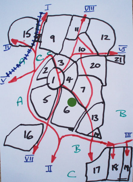 Residential Areas of Melksham This diagram shows the main residential areas of Melksham, and was drawn up to give newcomers who are looking to move into the town an idea of the different sections. Key The green marker shows the Well House Manor hotel - sponsors of this page. Black - Areas of Melksham 1. Town Centre 2. Historic Church Land 3. Older centre Area 4. Statton's Walk 5. Hazelwood Road 6. Kenilworth Gardens 7. Queensway 8. Spencer Gate 9. Scotland and Avon Roads 10. Inner Forest 11. Little John 12. Savernake Avenue 13. Snowberry Lane 14. The Spa 15. Shurnold and Roundstone 16. Berryfields 17. Bowerhill (Older section) 18. Bowerhill (Magister Road) 19. Bowerhill (Hornchurch Road) 20. Blackmore Road 21. Snarleton Lane Green - Other use areas A - Flood plain of the river Avon B - Agricultural C - Industrial / Commercial Blue - Out of town (village listing) I - A350 towards Chippenham - Beanacre - Lacock II - A350 towards Trowbridge - Semington (South End) III - A365 towards Devizes - Seend - Sells Green IV - A365 towards Bath, also Corsham - Whitley - Purlpit - Atworth V - B3017 towards Bradford on Avon - Broughton Gifford - Holt VI - A3102 towards Calne - Sandridge - Westbrook - Bromham VII - Semington Road - Semington Road - Semington North End Red - Main roads and connections Blue track - Passenger Railway Line |
OPTIONS AVAILABLE TO YOU
You may follow links in the text to explore other topics.Extra link - Return to the HomePage of this share system
STATUS AND CONTROL
You are a guest
This is a page from Well House Consultant's shared information directory. Learn about our shared information system.
Further Information
Follow us on ...
 |  |
PH: 01144 1225 708225 • FAX: 01144 1225 793803 • EMAIL: info@wellho.net • WEB: http://www.wellho.net • SKYPE: wellho
PAGE: http://www.wellho.net/share/melkshamareas.html • PAGE BUILT: Fri Apr 5 18:43:09 2013 • BUILD SYSTEM: wizard